
By JoAnn Schwartz and Bjørn Watne
JoAnn — an American from California and the current Secretary for the TCC. Her favorite destinations are those off the beaten path.
Bjørn — a Norwegian who lives most of his life out of a suitcase between the Nordics and Asia; his list of TCC territories is only surpassed by his airline miles.
The following is a dialog between JoAnn and Bjørn, who met at the 2022 Malta conference and separately visited Northern Pakistan in the second half of 2022.
 J: It seemed like so many people were going to Northern Pakistan last year. I started in Lahore and saw the main sights of the Lahore Fort and Badshahi Mosque, but for me the highlight was the flag lowering ceremony at the Wagah border with India. It really was fun to see in person. From Lahore we drove to Islamabad, which is where I think you started your trip.
B: Yeah, that’s right! I was in Pakistan on business and got a tip from a colleague of mine that said I should try to make my way up to the mountains and the village of Skardu. A quick Google image search and I booked a return flight from Islamabad immediately looking to spend a long weekend up in the mountains. I put all my money on the flight conditions being good that day, but I understand you had some challenges with that going into the mountains.
Land Route to Hunza
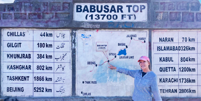
J: We had challenges going both ways. Our plan was to drive from Islamabad to Gilgit via the Babusar Pass and the Karakoram Highway (KKH) but it took us three tries to get over the pass route going there. Because of demonstrations in Chilas, the police held us for three hours before turning us back over the pass for safety reasons. The next day we drove back toward the pass but were told it was still closed. After about an hour we were able to proceed again without any issues. On the way back the flight we were supposed to take was cancelled — flying at an altitude below the highest mountain tops, flights don’t go when weather restricts visibility. It was a long drive back to Islamabad via the KKH and we didn’t have the shorter Babusar route option as snow had closed the road there. It made for a long day but was interesting to travel the length of this famous highway.
You had good luck with your flights. Where did you fly into and what did you do from there?
Air Route to Skardu
B: Indeed. Flights cancel 50% of the time, but mine did not. The weather was so good I was able to see both Nanga Parbat and K2 on the way to Skardu! Flights from Islamabad were cheap and frequent but if you decide to fly in, you should keep a couple of days open in your schedule to manage potential delays.
I can imagine overland transport being equally impressive given the nature you have to cover going from Islamabad to Gilgit. Did you feel safe? How long did it take? And what was your overall impression on taking the longer route?
Karakoram Highway (KKH)
J: Yes, it really was. The views just kept getting better as we drove north. About three hours before reaching Gilgit, there is a stop at the Nanga Parbat viewpoint where Himalayas, Karakoram, and Hindu Kush mountain ranges intersect— amazing to be in the middle of these giants.
The road itself is an experience. It’s impressive the KKH is kept open given the propensity to landslides in the area. It is paved, but it also looked in parts like the road edge could crumble at any moment. Because the KKH is the main route in and out of this area and a main link between China and Pakistan, there was a lot of truck traffic. I figured if they could manage, we should be ok in our van. That’s probably an overstatement of my confidence at the time.
Because of the delays getting over the Babusar pass, what should have taken 12 hours took almost two days. The drive back from Gilgit to Islamabad via the KKH was about 15 hours, though it can take much longer depending on what is happening with the road.
What activities were there in the Skardu area?
Skardu
B: Skardu has a lot to offer! Northwest you find Kachura and Soq valley where the more luxurious Shangri-La resort resides. The upper Kachura lake is a nice destination for a picnic, swim or a boat ride — a local favorite. Northeast lies Shigar valley that’s home to lush vegetation, an old fort-turned-museum-and-hotel, and several mosques dating back to the 14th century! The Kharphoco Fort, with a 270-degree view over Skardu, overlooks the Indus river. A newly made pathway allows you to walk a mere 20 minutes from the car park to the fort. Many tourists released their inner child at the Sarfaranga Desert, where both horses and 4x4s were available to race around the sand dunes and even a few microlights for those wanting to take in the view from above.
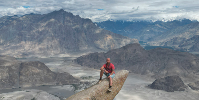
Speaking about the view from above, Marsur Rock sits above the valley. A twin to the similar-looking Norwegian rock “Trolltunga,” I had to make the trip. Getting there is a rather steep two-hour climb but you’ll be rewarded with some truly amazing views. I certainly felt the altitude though as the rock sits at almost 12,000 feet above sea level.
How about you? Did you get to see any of the sights? Or national parks? Of the latter there are quite a few it seems.
Hunza
J: We used Karimabad in the Hunza valley as our base, staying at the three-star Mulbery Hotel, with its five-star views of the surrounding towering mountains. The Armani Taste Point restaurant next door was my favorite of the entire trip.
This area has the 700-year-old Baltit Fort, the 1,000-year-old Altit Fort, and Ganish Village as some of the sights. We also visited the Hopper Valley and Nagar glacier. A bit farther out, continuing on the KKH, is Ataabad lake, formed by a huge landslide in 2010 that submerged multiple villages as well as the KKH which has since been rebuilt above lake level. The Hussaini suspension foot bridge straddling the Hunza river provides some adventurous fun as it is missing half the boards. Watch your step! The glacier and mountain range views around Passu were breath taking.
Of note for TCC members is the area we were both in counts as a visit to Kashmir, the portion of the former Princely State of Kashmir under Pakistani control.
Deosai National Park
B: Indeed! I actually had my eye on that territory before going, but another key objective for me was to visit the Deosai National Park. Called “the roof of the earth,” this is considered the second highest plateau in the world at an average of 13,500ft above sea level. The drive from Skardu up to the plains is a spectacular 1.5-2hr drive in itself with breathtaking views once you arrive at the edge of the plateau. We spent a full day crisscrossing the plateau in a 4×4 and saw both marmots and wild horses roaming the plains. As an added bonus the less chilled of us even managed a plunge into Sheosar Lake. At 13,589ft above sea level, it is one of the highest lakes I’ve visited.
I would definitely recommend a trip to Deosai National Park and there are also many options for camping (or glamping) to get those pristine views of an uninterrupted night sky with all its stars and sparkles. If you’re lucky, chances are you might even catch a glimpse of a Snow Leopard! Truly amazing place, and so very reachable from Skardu.